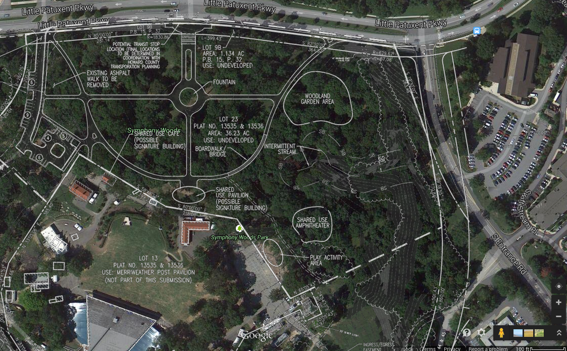
Proposed pathways and other features of the 2012 version of the Symphony Woods plan from Cy Paumier and associates. Click for high-resolution version. Adapted from sheet 3 of FDP-DC-MSW-1, Downtown Columbia Merriweather-Symphony Woods Neighborhood Final Development Plan.
I previously gave my understanding of how Cy Paumier’s plan for Symphony Woods won the support of the CA board and others whose opinions mattered, in large part because at the time it represented the only real alternative to a proposal from General Growth Properties that was seen as too destructive to the character of the woods. But was it actually a good plan? In this post and the next I leave the politics behind and look at the Paumier plan itself.
A 2009 Baltimore Sun article spoke of Cy Paumier as having “long dreamed of turning Symphony Woods into a sort of American suburban Tivoli Gardens,” the venerable Copenhagen amusement park that (among other things) inspired Walt Disney when creating Disneyland. The real-life Tivoli Gardens is a very intensively developed urban park that crams five roller coasters and over three dozen other rides and attractions into 21 acres, only a slightly larger area than the 16 acres covered by the northern portion of Symphony Woods. Whatever might have been Paumier’s ultimate vision for Symphony Woods (or, for that matter, what it might yet be), his plan as proposed was not nearly so ambitious.
The plan evolved somewhat over the years, including a “concept diagram” in 2008 or 2009, a more complete plan presented to CA in 2009, a plan presented to the Howard County Design Advisory Panel in 2011 [PDF], and the final development plan submitted to the Planning Board in 2012 [PDF].1 However pretty much all incarnations of the plan reflected a consistent set of design choices:
The northern portion of Symphony Woods would be divided into two distinct areas, one with formal pathways and one without. These correspond roughly to the “lawn” and “forest” areas respectively. (See my previous post for representative pictures.) The 2009 concept diagram (which can be found on slide 3 of the Design Advisory Panel presentation) shows this most clearly, with a large circle drawn in the lawn area, outlined by formal curved pathways around a central “sunlit lawn,” and a somewhat smaller circle drawn in the forest area, with irregular pathways passing through a “woodland garden.” The formal pathways in the lawn were to be paved for general use by everyone (or almost everyone—see below), while the irregular pathways in the forest area were apparently intended to be gravel only.
The formal pathway area would have a north-south axial alignment with the mall access road leading into the Mall in Columbia. In plans from at least 2011 on the main proposed pathway (in one section 40 feet wide, including a central grassy median) would head directly south from Little Patuxent Parkway, aligned with the relatively short mall access road to the north of Little Patuxent Parkway. The pathway then would go straight across the lawn area and end just north of the Merriweather Post Pavilion property line. Two other major pathways would run from that southern terminus to points on Little Patuxent Parkway to the east and west of where the north end of the main path would terminate. These other pathways were to be roughly (but not exactly) symmetrical to each other.
With one exception all park features other than pathways were to be located as close as possible to the Merriweather property line. At various times the proposed features included a pavilion at the southern end of the main north-south path, a café (sometimes envisioned as being part of the pavilion, and sometimes seen as a separate building to its west), a children’s play area right next to the Merriweather VIP parking lot, and a small outdoor amphitheater just east of the children’s play area. A fountain was the only feature not to be located next to Merriweather; it was proposed as being on the main north-south pathway, either just north of the pavilion (in the concept diagram and apparently in the 2009 plan) or in the middle of the lawn area (in later plans).
What about tree removal? After all, minimizing the number of trees removed from Symphony Woods was long touted as an important factor in preferring the Paumier plan to the GGP proposal, and apparently in some people’s minds it was and remains the only factor worth considering. Although the Paumier plan was certainly less disruptive to the woods than the GGP plan (which proposed constructing multiple buildings in the northern part of Symphony Woods), the formal pathway geometry in the Paumier plan unfortunately meant that more trees would need to be removed than with pathways explicitly routed around trees as needed.
The estimates of the number of trees to be removed have varied among different incarnations of the Paumier plan. In the recent announcement of his April 19 rally Cy Paumier claimed that “Only 30 existing trees were to be removed to implement the walkway plan that was approved by the Columbia Association Board in 2009.” Note that the 2009 plan referred to is not the plan that was actually submitted into the Howard County planning process, but an earlier plan that was later revised. Also, based on the wording of Paumier’s statement this figure of 30 trees removed was apparently for walkways only and not for park features.2
In a July 2012 letter to the Baltimore Sun Cy Paumier wrote that “Between 50 and 60 trees will need to be removed to construct the Symphony Woods Park walkways.” This figure is for the design submitted to the Planning Board. At the actual Planning Board hearing three weeks before, Charlie Bailey of Mahan Rykiel Associates (the landscape architects for the plan) testified that “the current design predicts a worst-case scenario of 64 trees to be removed within the 16.1 acre project area.” Note that again these figures do not include any trees removed for construction of the proposed park structures.3
I’ll take a breather now and return tomorrow with my verdict on the Paumier plan.
I’m not aware of any definitive online source for the 2009 plan presented to CA. If anyone can point me to relevant documents I’d be glad to add links to them. (I did find a Slater Associates web page that may preserve an image of this plan.) There apparently also were additional plan versions considered by the CA board, but I can’t find online public documents about them either. Finally, there were plan diagrams included with the presentation to the 2011 pre-submission community meeting prior to the Design Advisory Panel meeting; they were apparently identical to the ones presented at the DAP meeting. ↩︎
I could not find any independent public record of estimates on tree removal for the 2009 plan. ↩︎
By comparison the current Inner Arbor estimate (as contained in the latest “by the numbers” document [174MB PDF]) is for 31 trees to be removed for construction of all walkways and all proposed park structures. ↩︎