After discussing the characteristics of the previous Cy Paumier plan for Symphony Woods it’s time for my verdict. Spoiler alert: It’s not favorable—not a horrible plan, but one whose key design choices left it flawed in several ways.
Since I finished up with tree removal in my last post, I’ll start with it here. As I noted previously, the number of trees requiring removal is dependent on the exact version of the Paumier plan being discussed, and was inflated by the choice of formal rather than meandering walkways in the design. In his rally announcement to “save Symphony Woods” Paumier quoted a figure of 30 trees requiring removal, which is ostensibly one lower than the Inner Arbor estimate (but see below) and substantially lower than the figures of 50 to 60 or more trees presented to the Howard County Planning Board and documented in Paumier’s own 2012 letter to the Baltimore Sun. The key point here is that Paumier has abandoned the 2011 and 2012 versions of the plan that the Columbia Association submitted to the Howard County planning process, and is referencing an older version of the plan from 2009, a version the CA board decided later to revise.
If that plan is the one pictured on the Slater Associates web site then it did not have the north-south or east-west walkways present in later versions of the plan, and the fountain was proposed to be located next to the pavilion rather than midway between the pavilion and Little Patuxent Parkway. Reducing the number of walkways obviously would require fewer trees to be removed. Also, Paumier’s wording in the announcement implies that the estimate for tree removal includes only walkways and not proposed park features like the pavilion and fountain (much less the children’s play area and amphitheater); adding all those features back in would require more trees to be removed. By comparison the Inner Arbor estimate of 31 trees is for all walkways and all proposed features.1
Now, back to the other disadvantages of the Paumier plan, disadvantages that exist to one degree or another in all versions of the plan that have been proposed:
First, in its attempt to avoid disturbing the forest area of Symphony Woods the Paumier plan would have limited the ability of people to enjoy walking through that area, which as I previously mentioned is the most scenic part of the northern portion of Symphony Woods. From the viewpoint of a visitor the apparent intent of the Paumier plan would have been to keep you on the main walkways in the lawn area, and to discourage you from venturing into the forest area at all. Some people probably wouldn’t have been able to go into the forest area even if they wanted to, since from the extant plan documents it’s not clear that any paths in the forest would have been accessible to people using wheelchairs or who otherwise had difficulty walking.
Second, the formal geometry of the walkways and the north-south axial alignment of the main walkway (present in the plans from 2011 on) were arbitrary, inconsistent with the character of Symphony Woods, and forced design choices in other areas that made the plan less than optimal. Although it’s certainly true that the Mall in Columbia is north of Symphony Woods, and that Merriweather Post Pavilion is south of this portion of it, there is no real north-south alignment of properties and features. In particular Merriweather Post Pavilion is not just off-access but actually rotated with respect to the mall access road and north-south walkway.

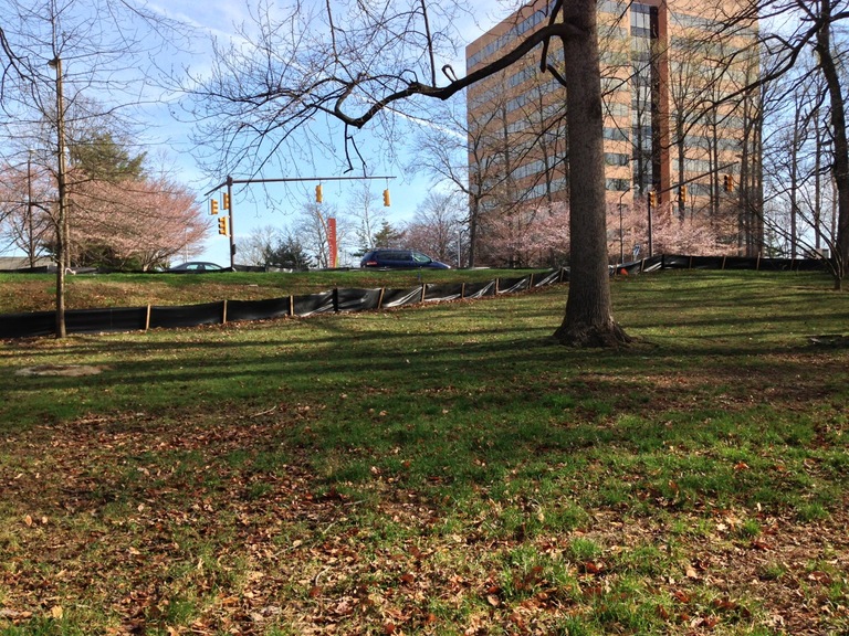
Looking up to Little Patuxent Parkway and the mall access road, near the northern end of the proposed main north-south walkway in the Paumier plan. Click for high-resolution version.
This desire to force a formal walkway geometry onto an irregularly shaped Symphony Woods property had various negative consequences. Since there is a drop going from Little Patuxent Parkway into Symphony Woods across from the mall access road, the main north-south walkway would have had to go down a set of stairs at its northern point, again potentially causing accessibility problems.2
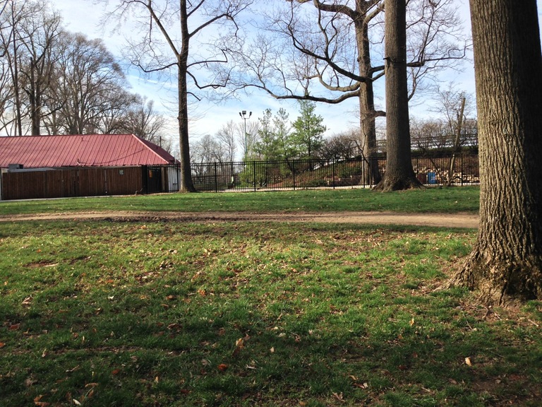
Since Merriweather Post Pavilion itself (i.e., the amphitheater structure) is not located at (or even visible from) the southern end of the proposed north-south walkway, the plan put a small pavilion building there to provide a visual endpoint to the walkway and a destination for visitors. This pavilion would have been at probably the worst possible location in terms of integration with Merriweather, since it would have butted up against the Merriweather fence next to the restrooms and at some distance from the eastern and western entrances to Merriweather. The secondary east-west walkways had a similar problem: They would also have terminated on the south end at the pavilion, well away from the Merriweather entrances, and due to the attempted symmetry with the west walkway the northeast end of the east walkway at Little Patuxent Parkway would have been located in the middle of the block, some distance away from any crosswalks.

Near the south end of the proposed main north-south walkway in the Paumier plan, showing the Merriweather fence and restrooms. Click for high resolution version.
Given the formal and circumscribed walkway geometry the Paumier plan would have offered limited opportunities to take a lengthy walk in Symphony Woods. When I walked in the woods myself it took about 20-30 minutes not counting stops. However in the Paumier plan the walk along the main north-south walkway would take no more than two and a half minutes even walking slowly (based on a timing I did on my own walk); a complete walk into the park on the main walkway and out again on one of the secondary walkways (or in on one secondary walkway and out on the other) would likely have taken well less than ten minutes.
Third, although the Paumier plan put almost all its proposed structures as close as possible to Merriweather Post Pavilion, those structures, and the design in general, were not well integrated into Merriweather. As noted above, the main north-south walkway of the Paumier plan would have terminated at a pavilion structure across the fence from the back of the Merriweather restrooms and some distance away from the main Merriweather entrances, as would have the east and west curved walkways. Although there is some mention in the plan documents of trying to get a gate in the fence at that point, and of needing to cooperate with the Merriweather operators and Howard Hughes (which had taken over from GGP), there was no overall strategy presented for how to integrate the pavilion and other plan features with the Merriweather property. As another example, the children’s play area was proposed to be right next to the Merriweather VIP parking lot—not exactly an ideal choice I would think.
Finally, leaving aside the actual design choices, the Paumier plan seems rather underspecified for a plan that was over three years in the making. For example, the Design Advisory Panel presentation does not show detailed draft designs for the pavilion, the fountain, the children’s play area, or the outdoor amphitheater. (It contains only a “for discussion purposes only” concept drawing of the main walkway, fountain, and pavilion, and a couple of pictures of representative restroom structures from other parks.) Such detailed designs were not part of the submitted final development plan either. Granted, in the context of Howard County planning a “final development plan” is not really final in the sense most people would normally think of, since it must be followed by a more detailed “site development plan.” However I still find it rather surprising that a plan initially conceived in late 2008 was so sketchy and incomplete as late as the middle of 2012, especially given the support provided by CA from 2010 on.3
As I’ve mentioned previously the Paumier plan was revised multiple times over the years to tweak it in various ways. However I don’t think simple tweaks would have been sufficient to solve the problems I mentioned above, since they stem from aspects of the plan that remained consistent, including trying to overlay a north-south alignment on a park that runs east-west, using a formal geometry for walkways, and putting structures in close proximity to the Merriweather Post Pavilion property line without truly integrating them with Merriweather itself. The Paumier plan in its various incarnations would not and could not “save Symphony Woods” except in the very narrow sense of being a better alternative to the GGP plan of 2008. The GGP plan has been consigned to the dustbin of history, and today we can do better than the Paumier plan.
This is not just my opinion as an amateur architecture critic. The Howard County Design Advisory Panel echoed these criticisms in its comments on the 2011 design, for example, questioning the need for a north-south alignment: “Aside from the mall axis extension and a loose connection to Merriweather Post Pavilion (MPP) there seems to be no rationale for the path organization.” As reported in a Baltimore Sun article, members of the panel also thought the plan lacked an overall vision and narrative, and emphasized the need for a park that could set standards of design excellence for the rest of downtown Columbia.
In its decision on the Final Development Plan [PDF] presented in July 2012 by CA, the Howard County Planning Board, while approving the overall concept of a park with walkways and various features, including a shared-use amphitheater and café, focused its attention on the formal walkway geometry and the poor integration with Merriweather Post Pavilion. It recommended that removal of trees be minimized by “aligning paths around healthy trees and minimizing grading.” It also called for “continuing coordination between Columbia Association and Howard Hughes Corporation regarding a shared vision and design for Merriweather-Symphony Woods as a unique cultural and community amenity,” and “development of a coordinated plan for the neighborhood.”
Just as Cy Paumier had come forward in 2008 to offer an alternative to GGP’s plan for Symphony Woods, another local Columbian and former Jim Rouse associate, Michael McCall, subsequently came forward with his own alternative plan, which like the Paumier plan in its time was then adopted by the CA board as its preferred plan moving forward. In my next post I’ll discuss that “Inner Arbor” plan as both a continuation of and improvement on the Paumier plan.
In his rally announcement Paumier also claims that in fact more than 100 trees will have to be removed for the Inner Arbor plan, basing his claim on a 2010 CA study. It’s worth noting that the Baltimore firm Mahan Rykiel Associates served as landscape architect for the Paumier plan and is currently the landscape architect for the Inner Arbor plan. Since Mahan Rykiel prepared the tree removal estimates for both plans, and presumably would have been aware of the 2010 CA study when preparing these estimates, I’m inclined to accept their estimates as accurate absent any compelling evidence to the contrary. ↩︎
On slide 6 of the Design Advisory Panel presentation [PDF] these stairs are identified as “grand stairs to transition down steep grades.” No ramps are shown as alternatives to the stairs; presumably people arriving from the mall who were not able to negotiate the stairs would have had to go down Little Patuxent Parkway a few hundred feet to one of the other entrances. ↩︎
I have no inside knowledge about this, but it’s certainly possible that at least part of the delay was due to micromanagement of the design process (aka “bikeshedding”) by the CA board. If a January 2012 Baltimore Sun article is any indication, the board seemed to spend a lot of time discussing—and disagreeing about—the design details of the proposed fountain. In this case, and perhaps others related to the Paumier plan, coming to consensus and making a final decision appeared to require multiple meetings stretched out over several months. ↩︎