tl;dr: When we expand the Howard County Council let’s make it more reflective of the people it serves.
[This is part 2 of a seven-part series. See also part 1, part 3, part 4, part 5, part 6, and part 7. I also wrote a follow-up post that can be viewed as an alternative to part 5.]
In my previous post I proposed a comprehensive overhaul of the way we elect the Howard County Council:
- Expand the council from five to fifteen members.
- Reduce the number of council districts from five to three.
- Elect five members in each district using ranked choice voting.
- Draw the district lines using an automated process overseen by an independent nonpartisan commission.
In this post I discuss why having three districts is better than having fifteen districts (or no districts at all) when it comes to promoting diversity on the Howard County Council.
Why three council districts? Why not fifteen?

Racial and ethnic population percentages for each of fifteen Howard County Council districts, based on an example district map generated by the Auto-Redistrict program. (Click for a higher-resolution version.) Graph by Frank Hecker; made available under the terms of the Creative Commons CC0 1.0 Universal (CC0 1.0) Public Domain Dedication.
Why reduce the number of council districts from five to three? With fifteen council members shouldn’t we have fifteen council districts?
The first problem is that electing one council member in each of fifteen districts can dilute the voting power of minorities. Look at the graph above, which shows the population percentages for various racial and ethnic groups within an example set of fifteen council districts. (The associated district map was drawn by the same automated system described in the next post.)
As of the 2020 Census non-Hispanic Whites make up less then half of Howard County’s population, but they would still form the largest voting bloc in thirteen of the fifteen example districts. There is only one example district in which Blacks would form the largest voting bloc, and only one in which Asians would.
If such a map were to be adopted, and if voters tended to vote for people of their own race or ethnic group, the result would likely be a White-dominated council, similar to what’s been the historical norm in Howard County. It’s possible that there might be only one Black council member out of fifteen (down from one in five currently), and only one Asian council member.
Creative drawing of district lines could “solve” this problem, by lumping minority populations into a few select districts where they might have a chance of electing one of their own. But this would be at the expense of minority voters in other districts. (This is similar to the situation with the current council districts, in which Black candidates have been elected in District 2 but not in any other districts.)
The same techniques used to draw district lines to favor particular racial or ethnic groups also can be—and have been—used to favor one political party over another. This brings us to the second problem:
Drawing district lines for fifteen districts is a lot of work compared to drawing them for five districts, and offers more opportunities for partisan gerrymandering and endless political fights over redistricting. The process of Howard County Council redistricting is contentious enough—I literally wrote the book on this—so why make it even more divisive and time consuming than it already is? The fewer districts, the less opportunity for gerrymandering.
Howard County originally had five council members representing the entire county, with no councilmanic districts. Howard County now has over three times the population as it did then. So you can think of the proposed scheme as a return to the county council’s roots, with each of the three districts being comparable in population to Howard County fifty years ago, and each district having five council members representing it, just as Howard County as a whole did back then.
But . . . the original Howard County Council elections had a fatal flaw, one which we need not and should not replicate. I discuss that in the next section.
Why not elect council members at-large?
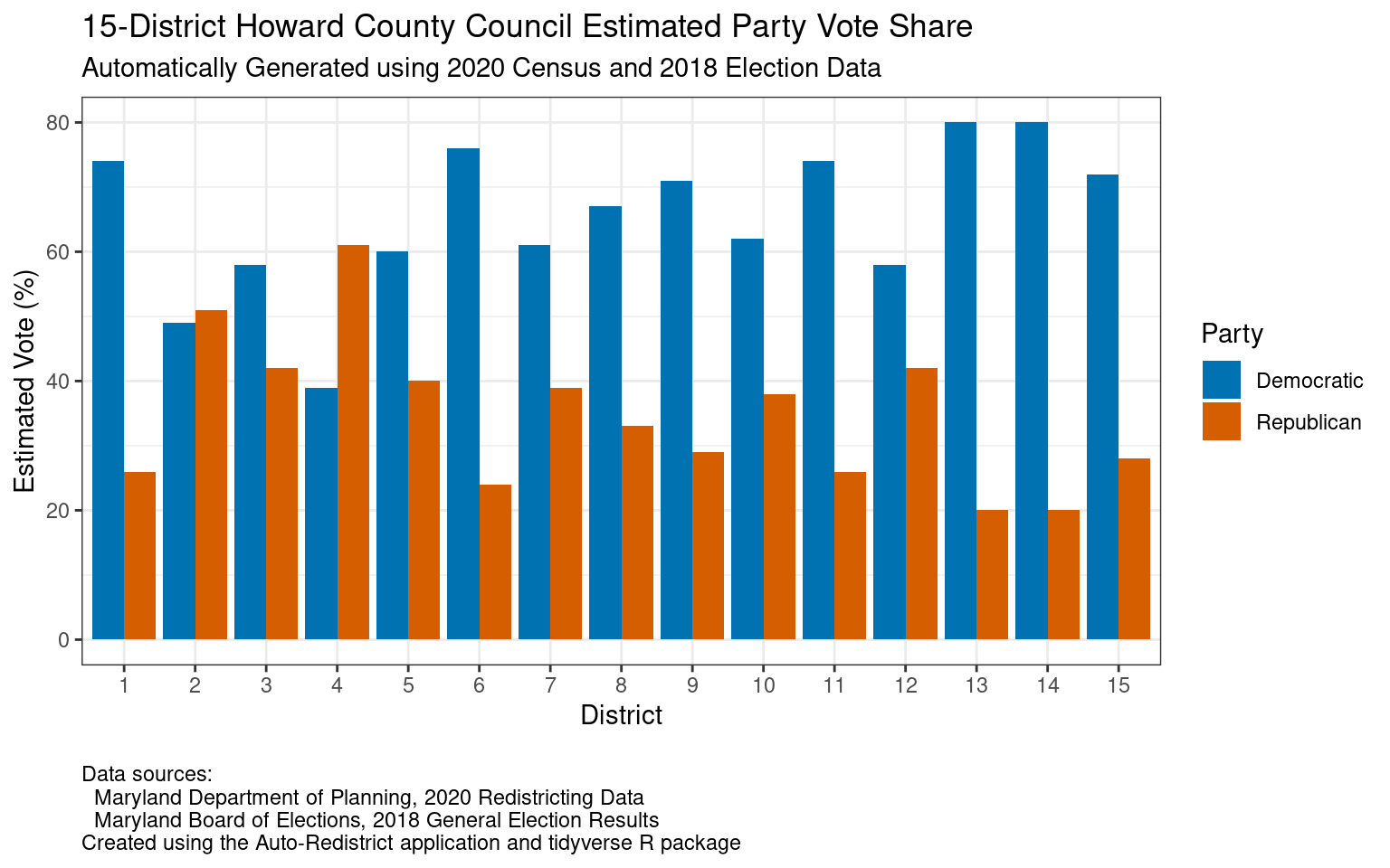
Estimated vote share for each of the two main political parties for each of fifteen Howard County Council districts, based on an example district map generated by the Auto-Redistrict program. (Click for a higher-resolution version.) Graph by Frank Hecker; made available under the terms of the Creative Commons CC0 1.0 Universal (CC0 1.0) Public Domain Dedication.
OK, so having fifteen districts may not be a good idea. Why not eliminate districts altogether, and elect all fifteen council members in county-wide at-large elections? Or have three districts as suggested, with five members chosen in at-large elections in each district? Or have a smaller number of districts (say, nine or ten) and then elect the remaining members at large, similar to how Howard County Board of Education elections work?
The problem here is that at-large elections can entrench the dominance of majorities and work against minorities: since voters can vote for multiple candidates, and the candidates with the most votes win, if a 51% majority votes as a unified bloc for a slate of at-large candidates, they can succeed in having all of their candidates being elected. The 49% minority would then have no representaion at all.
This is not just a theoretical concern. It’s exactly what happened in Howard County in the first years after it moved to a council form of government: Because all five members were elected at-large, and because Democrats formed a majority of voters (in large part due to the establishment and growth of Columbia), the council was dominated by Democrats. In fact, at one point there was no Republican council member at all.
The same thing would happen with an expanded fifteen-member council elected in at-large elections. In fact, it would likely be even worse than in the 1970s because the ratio of registered Democrats to registered Republicans is much larger now.
The push to switch the Howard County Council from at-large elections to elections by district came mainly from the Republican party, because Republicans were under such a disadvantage in at-large elections. But election by districts is not a panacea for Republican concerns, especially when the number of districts is large.
Suppose we abandon the idea of electing fifteen council members in county-wide at-large elections and go back to the idea of electing one council member in each of fifteen districts. Republican candidates would then be severely disadvantaged if we used our hypothetical example set of fifteen districts (which was created by an automated system designed to minimize partisan advantages).
Although there’s a substantial body of Republican voters across the county, as shown in the graph above there is only one district out of the example fifteen districts in which Republican voters would form a clear majority, and only one other district where their numbers would be comparable to Democratic voters. (This is based on estimates derived from the 2018 county council elections.)
If there were only three districts, and members were chosen at-large in each district, the Republican party would still have the problem of majority dominance. There are so many Democrats relative to Republicans that it would probably be possible to draw district lines such that all three districts had Democratic majorities. Using at-large elections to elect five council members within each district would allow those majorities to elect full slates of Democratic candidates in those districts, again locking Republicans out of county council representation.
So if we want to have only three districts, with five members in each, and we don’t want to elect members using at-large voting within each district, how should we elect each district’s members? That’s the topic of my next post.
For further exploration
For the numbers and code behind the graphs above showing the racial, ethnic, and party breakdowns for a hypothetical fifteen districts, as well as the generated fifteen-district map, see “Howard County Council Expansion, Part 2.”