tl;dr: A county that cares about inclusivity needs an approach to council redistricting that is open to all, transparent, as fair as possible, and not controlled by partisan interests.
[This is part 4 of a seven-part series. See also part 1, part 2, part 3, part 5, part 6, and part 7. I also wrote a follow-up post that can be viewed as an alternative to part 5.]
In the first post in this series I proposed a comprehensive overhaul of the way we elect the Howard County Council:
- Expand the council from five to fifteen members.
- Reduce the number of council districts from five to three.
- Elect five members in each district using ranked choice voting.
- Draw the district lines using an automated process overseen by an independent nonpartisan commission.
In this post I discuss how to draw district lines for the proposed three districts, with ranked choice voting used to elect five members in each district.
Automated redistricting for everyone
The Auto-Redistrict application can be downloaded at no charge and run on Microsoft Windows, macOS, or Linux. (Click to go to the Auto-Redistrict web site.) As input you can use freely-available population and election data released by the Maryland Department of Planning and the Maryland Board of Elections respectively. Auto-Redistrict © 2013–2021 Kevin Baas; licensed under the terms of the GNU General Public License 3.0.
At present the boundaries of the five Howard County Council districts are created and proposed by an appointed redistricting commission, and then adopted by the county council. Each of the two parties appoints an equal number of candidates for the commission and the county council appoints the chair of the commission.
In practice the district boundaries are actually drawn by computer, with each of the two parties using redistricting software to draw potential districts so as to favor their own cause. Since Democrats currently have a majority on the county council, the district boundaries adopted will be those that help get Democrats elected to the council.
Ordinary voters and third parties have little or no influence over this process: the rules are designed to exclude third parties from the redistricting commission, and access to redistricting software has traditionally been restricted to the two major parties.
However there’s no longer any reason (other than inertia and a desire to maintain control) for county council redistricting to be done in this way. Any interested person can now download free software that can automate the process of redrawing district boundaries. They can also download the data that’s required as input to the redistricting software, including population data derived from the US Census, digital maps of precinct boundaries, and past election results. Armed with this software and data they can create their own proposed districts.
That’s exactly what I’ve done for this series of posts. I used the Auto-Redistrict software (created by Kevin Baas), in large part because it supports creation of multi-member districts elected using ranked choice voting. Not only is it free but its source code is also available, so that the way it works can be inspected for correctness and potential biases.
Running Auto-Redistrict to create a three-district map
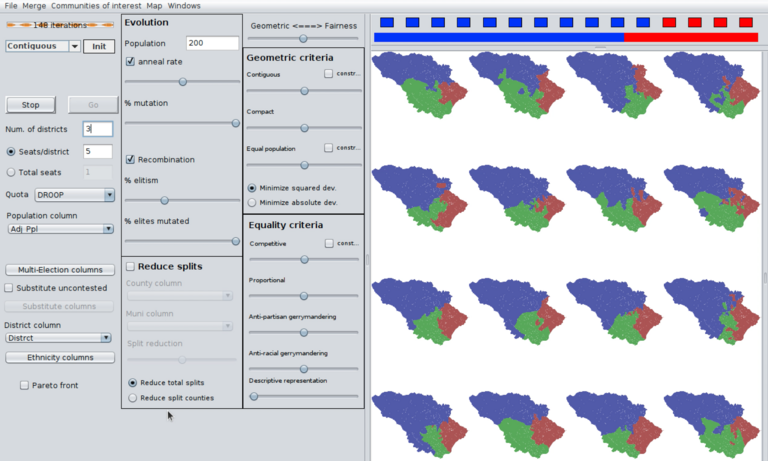
The Auto-Redistrict software generates multiple maps on each iteration, evaluates the maps according to various criteria, selects the top maps, and recombines and randomly changes them to create a new set of maps for the next iteration. This screenshot from a video of running the software shows the top sixteen maps on iteration number 148. (Click to watch the full video.) Video by Frank Hecker; made available under the terms of the Creative Commons CC0 1.0 Universal (CC0 1.0) Public Domain Dedication.
As input to the program I used the public data released by the Maryland Department of Planning after each decennial census for use in Congressional redistricting. The data files include precinct boundaries and populations for each precinct, including population figures broken down by race and ethnicity to help ensure that districts are not drawn to disadvantage particular minority groups.1
I also used as input to the program the public data on election results released by the Maryland Board of Elections. This can be used to help ensure that districts are not drawn to disadvantage particular political parties. In this case I used results from the 2018 general elections for Howard County Council, since those are the results most relevant for county council redistricting.
(Since there was no Republican candidate in District 3, I estimated the potential vote share for a hypothetical Republican candidate in that district. I also did further estimation to account for early voting and absentee voting, which are not reflected in the official precinct-level results.)
The Auto-Redistrict program allows you to tweak various parameters representing various trade-offs between different goals: for example, how important is it that the districts’ populations be as equal as possible, or that districts be as compact as possible? In my case I used all the default settings.
Howard County has over a hundred precincts. The number of ways in which those precincts could be combined to form three districts is much too large for a person to check each possible district map, and even too large for computers. The Auto-Redistrict software therefore takes a different approach: it generates a set of random maps, evaluates them according to the various criteria being used (compactness, competitiveness, etc.), and then selects the best maps to be carried forward. It then mimics biological evolution, creating a new set of maps by combining different maps together to form new ones, while also introducing some random changes (analogous to mutations).
This process—evaluating maps, picking the best ones, using them to create new maps, and then repeating the evaluation—continues until the generated maps become more and more alike, representing the “best of the best” in terms of meeting the desired criteria. In my case I stopped the program after over eight thousand iterations and went with the last map produced. Using a modern laptop the whole process took about half an hour from start to finish.
“Automated” doesn’t mean “nonpolitical”
Having extolled the virtues of using software to automate the process of doing redistricting, I now have to stop and issue a caution: just because the process can be automated using software designed to handle the mathematics doesn’t mean that we can simply “leave it to the mathematicians”. There are multiple aspects of automated redistricting that entail decisions that are political in nature.
That means in turn that an inclusive approach to redistricting requires the inclusion not just of people who can run software like Auto-Redistrict, but also of people who can question the assumptions and data that go into the software, as well as the results that come out of it. Hence my suggestion that redistricting needs to be overseen by an independent commission that is (as much as possible) designed to be nonpartisan and representative of all the major groups with a stake in the results.
As but one example, I made a judgement call when deciding what party-related data to include in the input to Auto-Redistrict. In particular, I chose to use only the results of the 2018 county council races, and did not use the results of the 2018 county executive race (which had a higher vote share for Republicans). Others may quibble with that decision.
I also haven’t considered using detailed voter registration data (e.g., registered Democrats vs. registered Republicans in each precinct). To my knowledge that data is not fully publicly available, so if I were able to obtain detailed voter registration data I would not have been able to present my analysis in a fully public and transparent manner. Making that trade-off is, again, an inherently political decision: should I have prioritized possibly doing a better job of drawing maps at the expense of excluding people without access to the same data?
Other decisions are involved in how redistricting software like Auto-Redistrict is configured to run. For example, I chose the default settings when prioritizing geometrical considerations like compactness of districts against considerations of fairness like balancing party, racial, or ethnic vote shares. Perhaps others might have had different priorities. Again, these become political decisions, and should not simply be left to the “experts” to decide.
So what I’ve done here in running Auto-Redistrict for my proposed fifteen-member three-district county council shouldn’t be construed as a perfect effort, not to be questioned, or even as the best that could possibly be done. It’s just one example out of many possible ones. In any case, in the next post I’ll present my particular results.
For further exploration
For more information on attempts to take redistricting out of the control of legislative bodies and put it in the hands of independent redistricting commission see:
- “Independent and Advisory Citizen Redistricting Commissions” is a list of links to information about states that have reformed redistricting to one extent or another.
For more on drawing district boundaries using computer sofware see:
- The Auto-Redistrict web site has more information about how the software works and how to run it.
- My document Howard County Council Expansion, Part 1, discusses creating the input data that Auto-Redistrict uses (Howard County precinct maps combined with demographic data and election results). It includes a detailed discussion of the measures I took to select particular data to be considered, and to estimate data where it was not available for one reason or another.
- My video “Howard County Council Redistricting with Auto-Redistrict” demonstrates how to run Auto-Redestrict to generate a district map for the proposed expanded Howard County Council.
The data provided by the Maryland Department of Planning actually goes down to the census block level. However for my purposes I found it more useful to aggregate the data to the precinct level, and then do redistricting based on precincts. ↩︎